Canada will feel the strongest El Niño in living memory mainly from late December, when a milder and drier winter is forecast to take hold.
The Pacific event’s broader effects on the country usually come late in the year, not when the ocean first warms, said Bill Merryfield, a research scientist at Environment and Climate Change Canada. It’s still developing.
An event still short of its peak
A regular El Niño comes every two to seven years; a super El Niño, roughly every 10 to 15. This one is expected to be the strongest in living memory. It begins with weaker trade winds, which push warm water from the western Pacific towards the central and eastern tropical Pacific.
For the pattern to count as El Niño, sea surface temperatures in the central and tropical Pacific must sit 2C or more above the long-term average. Daily ocean readings have already reached nearly 3.5C above the 1991-2020 average. The previous high, in 2015, was 3.08C.
The peak is expected in December. The European Centre for Medium-Range Weather Forecasts projects sea surface temperatures in the tropical Pacific rising about 4C by then.
They tend to sort of intensify as the winter sets in
Drier Prairies, warmer north
From December, the high latitude will turn much rainier in the western and southeastern United States, while the northwest US and the western Canadian provinces go drier, said Zeke Hausfather, a climate scientist with Berkeley Earth.
Hausfather examined eight of the past strong El Niños. Now, 12 of 13 modelling groups worldwide forecast 19% less rainfall in British Columbia, Alberta and Saskatchewan.
For the high latitude, starting in December, we're going to see much rainier conditions in the western U.S. and southeastern U.S., and we're going to start seeing drier conditions in the northwest U.S. and British Columbia, Saskatchewan, Alberta, the western provinces of Canada
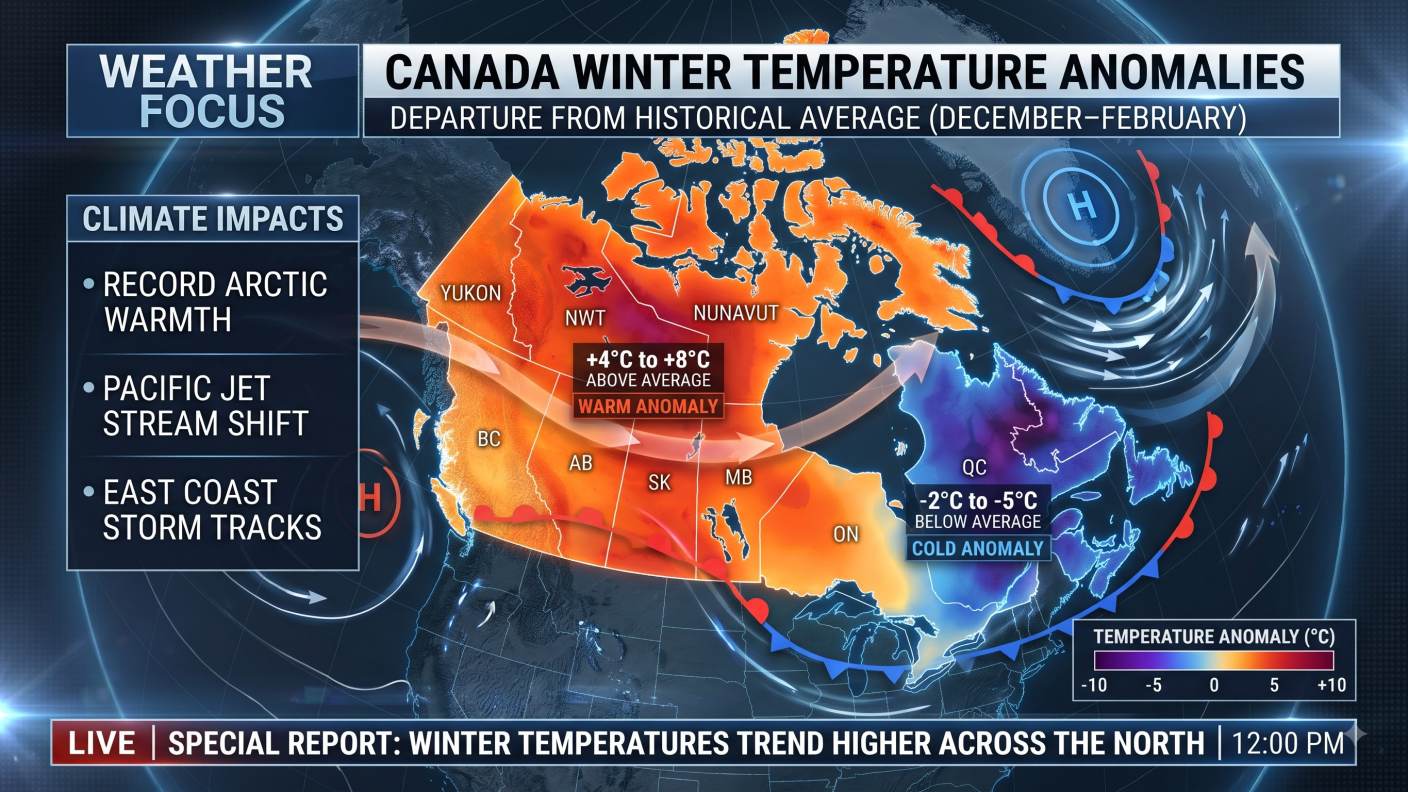
On temperature, the models agree that all of Canada runs warmer, with the effect most pronounced in central and northern Canada and felt to some extent in Eastern Canada.
All of Canada is warmer. And again, some of this is climate change, right? Because this is the 1991 to 2020 average
| Region | Outlook from December |
|---|---|
| British Columbia, Alberta, Saskatchewan | Drier; 12 of 13 modelling groups expect 19% less rainfall |
| Central and northern Canada | Warmest relative to the 1991-2020 average |
| Eastern Canada | Warmer to an extent |
| Atlantic Canada | No hurricanes or subtropical storms so far; one named hurricane in the basin; season ends 30 November |
| Canada overall | Unusually mild winters from coast to coast in past strong events |
We tend to see unusually mild winters really from coast to coast across the provinces. And as an example, winter temperatures during the last two events of this type in 1997 into 1998 [and] 2015 to 2016 in the Prairies were as much as five degrees or more above historical norms.
Atlantic Canada has already felt one effect, with no hurricanes or subtropical storms reported there. The Atlantic basin has had one named hurricane so far, and the season ends on 30 November.
A record year and a rising death toll
Berkeley Earth gives 2026 a 96% chance of being the warmest year on record, ahead of 2024.
The University of Chicago's Climate Impact Lab forecasts nearly 900,000 extra deaths worldwide over 10 months. It estimates 484,500 excess heat-related deaths have already occurred between June and September, with about 372,900 more expected over the next six months.
Over those six months, Nigeria is projected to record the highest toll, with more than 56,000 additional deaths. India follows with 55,000, and Indonesia with around 29,000. Together, China, Nigeria and India account for more than a third of the deaths linked to El Niño.
After the extreme heat many countries endured this summer, the projected total has risen sharply since a September 2026 report. The nearly 900,000 figure is a projection, not a count of deaths recorded so far.
Our research puts new forecasting capabilities to work to answer one of the most urgent questions we face: where is extreme heat likely to cost lives?
Being able to anticipate the deadly effects of extreme heat is a major step forward. It means we can identify where people face the greatest risks and give decision-makers a chance to act before lives are lost. The Tracker provides this information for the Super El Niño we’re living through today.
Why CO2 keeps climbing
CO2 levels rose 2.8 ppm from 2024 to 2025, a smaller increase than the year before, though the global average concentration still hit a record, the World Meteorological Organization reported. The strong El Niño of 2023 and 2024 helped lift the average by 3.5 ppm, the largest rise since modern record keeping began in 1957.
The most influential climate models, which inform negotiations, largely miss emissions from burning forests, thawing tundra and fermenting wetlands.
Fires in Indonesia have emitted an estimated 190 million tons of carbon so far this year, equivalent to about three-quarters of the country's annual CO2 emissions from fossil fuels. Brazil's space agency recorded 1,921 fire hotspots in Amazonas, up 202% from the same period in 2025.
We can expect to see a further increase in concentrations in 2026 because of fossil fuel burning and the development of a powerful El Niño which will impact land carbon sinks as it did in 2023/2024
The concentrations for 2026 and 2027 have not yet been determined.
In the tropics, El Niño tends to cut rainfall and raise temperatures, which can bring drought, weaker plant growth and more fire. Long dry spells, sometimes severe drought, can hit Australia, Indonesia and South Asia. In Indonesia, haze from the fire season has driven a spike in respiratory illness at home and a sharp fall in air quality in Singapore and Malaysia.
A study in the journal Science found that El Niños are more than 36% stronger than they were in the mid 1800s, before the industrial age, and have strengthened by 16% over the past 40 years. The pace of change is increasing. The Lancet Countdown on Health and Climate Change reported that extreme heat contributed to a record 710,000 deaths in 2023, and researchers attributed more than 70% directly to man-made warming.
Risks not yet landed in India
For India, which it described as the engine of growth for the world economy, the effect of weather such as this El Niño has yet to materialise, the International Monetary Fund said. It listed lower crop yields, higher food price inflation and the resulting hit to household purchasing power as the risks.
So these are risks that we see that India faces, but right now those risks have not materialised
So, we see it really as a risk going forward, and of course depending on whether that risk materialises, we will reassess our growth projections for India the next time in our January WEO update
But for now what we see is quite strong growth momentum in India, and it continues to be an engine of growth
The event is already being felt in Southeast Asia. Hundreds of local government units in the Philippines have declared a state of calamity, and agriculture and fisheries are affected. The Department of Agriculture proposed a P61.99-billion spending package to protect food production and livelihoods.
- TodayRecords already falling
Daily ocean temperatures near 3.5C above the 1991-2020 average, against a previous high of 3.08C in 2015.
- DecemberPacific peak
Sea surface temperatures projected to rise about 4C; peak expected some time in December.
- Late DecemberCanada onset
El Niño's larger effects across Canada generally begin, with drier air in the western provinces and milder air coast to coast.
- JanuaryIMF update
India's growth projections reassessed in the World Economic Outlook update.
The IMF will revisit its India growth forecasts in its January WEO update, if risks from the weather event materialise.